Land in North Carolina
[This file looks best when viewed with Internet Explorer at screen resolution of 1024 x 768 and setting "View/Text Size/Medium"]
While reading about the fact that most of the Pipes family passed through North Carolina in the late 1700's, did you ever wonder exactly where they lived while there? Would you like to go there and see the actual places they lived? I have tried to put together enough information, maps, pictures and drawings to allow you to get a pretty good picture of where they held land and where you could find that same land today. This article will focus on the two parcels of land held by John Pipes Jr. and John Pipes Sr. on both sides of the Yadkin River. Sylvanus Pipes also held land there, but I do not have copies of the deeds that would allow me to pinpoint where the land was located. That same fact holds true for the 50 acres that was listed for Phillip Pipes in late 1700 tax lists. See the end of the article for more info.
We know that sometime before 1770 John Pipes Sr. moved at
least part of his family to North Carolina from Morris County, New Jersey.
The only viable trail to make that move was the Great Wagon Road and the
move probably took from 4 to 8 weeks.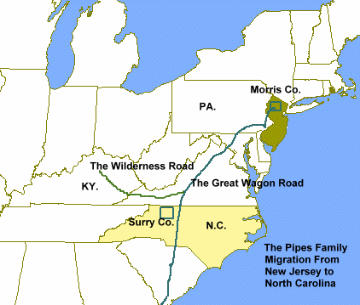
It is fairly certain that John Sr. lived as a squatter along with many others who arrived in the area at that time. He is mentioned in the diary of a Moravian missionary named brother Soelle as living in "Allin's Settlement" in conditions of poverty. This settlement was described as being at the foot of the brushy mountains, near "Fox Knob" and on the waters of Deep Creek. Using those descriptions it is possible to locate the general area. It is important to note that the Fox Knob area was also known (later) as Stars Peak and that Deep Creek runs everywhere in Surry and Yadkin Counties.
The map below shows the Great Wagon Road crossing the Yadkin at Shallow Ford on its way south. John Pipes Sr. was said to have been 40 miles west of here (Shallow Ford) by the Moravian Minister. Most travelers wishing to enter Surry County would do so at Shallow Ford, so named because during most times of the year, you could literally walk across the river. The mileage from Shallow Ford to the area where John Pipes was living in 1771 is about 20 miles "as the crow flies", which could be about a 40 mile trek cross country.
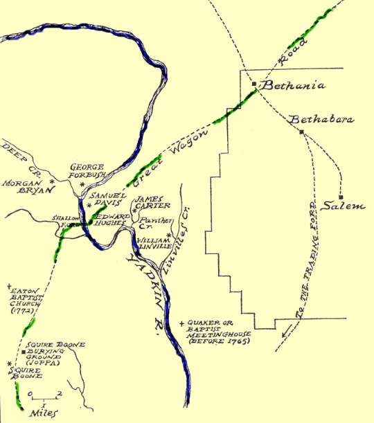
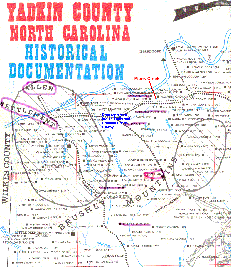
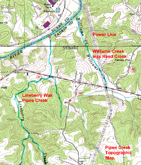
Here is another large file that shows the area called Allen's Settlement. It was located where the present city of Elkin/Joneboro reside. The Moravian minister said he found John Pipes near Fox Nob and close to John Swim's place in Allin's Settlement. This map also shows Pipes Creek, John Pipes' land grant on Pipes creek and note that the old Indian trail crosses the creek where present Hiway 67 crosses. That means that the "ford" mentioned later was most likely here. The old trails usually took the easiest path through the countryside.
A Large map of Allen's Settlement
But first we should orient ourselves to the area by looking at some maps of the area and identifying the landmarks. Remember that Yadkin county had not been formed yet and Surry County contained what is today Surry and Yadkin. They sit atop one another, Surry on the North, Yadkin to the South.
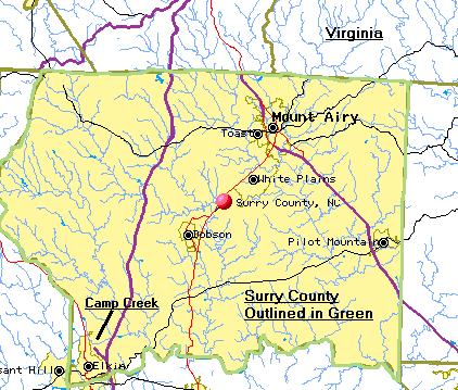 The
map at the left is present day Surry County. The area of our interest is
in the far southwest corner near the City of Elkin. John Jr. held land on
Camp Creek just north of the River and the city of Elkin.
The
map at the left is present day Surry County. The area of our interest is
in the far southwest corner near the City of Elkin. John Jr. held land on
Camp Creek just north of the River and the city of Elkin.
The red ball indicates the center of each county. The southern border of Surry and the northern border of Yadkin is defined by the Yadkin River.
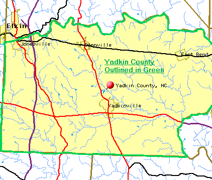
The land held by John Sr. is in present day Yadkin County and is located about where the double letter L is located in the word Jonesville on the map.
The location of land in relation to the Yadkin River is important because most of the deeds in that area made reference to the River. The land would be described as lying "North of the Yadkin" or "South of the Yadkin". The flow of the creeks in the area should be noted. The creeks south of the River flow north to the river and those north of the river flow south to the river.
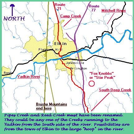 This
map shows the area near the City of Elkin in more detail and also adds the
landmarks that we mentioned earlier.
This
map shows the area near the City of Elkin in more detail and also adds the
landmarks that we mentioned earlier.
Disregard the writing under the map as we now know that Pipes Creek was much later called Lineberry Creek on County Maps.
This map will help you put things in context, especially if you read the account of Brother Soelle and try to locate "Allin's Settlement on Deep Creek".
The next thing we need to establish is the location of "Pipes' Creek". The name has been changed recently (sometime after 1960) by the USGS to Lineberry Creek, and is marked that way on most modern State and County Maps, although I understand that most older residents of the area still call it Pipes' Creek or in some cases Piper's Creek. The Creek is located on the map above as the one lying between Stars Peak and the river. The letter "K" on the word "Knobbs" lies right on the creek. It is the third of four major creeks that lie west of Jonesville. The following map shows Pipes' Creek and the land held by John Sr. in relation to Elkin/Jonesville.
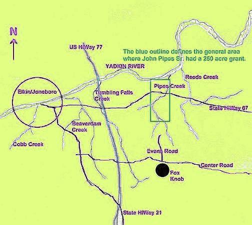
Note: The blue outline referred to on the drawing may appear to be green on some monitors.
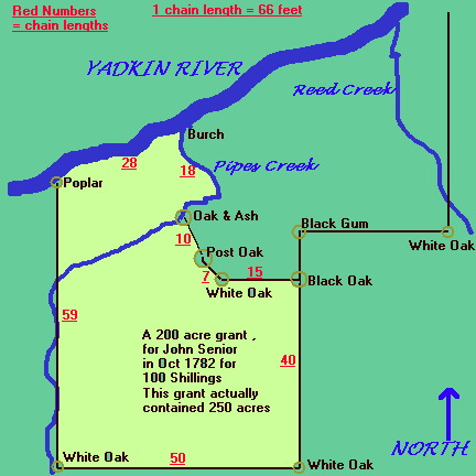
In 1782 a land grant was recorded in Surry County for John Pipes Sr.; This grant was made by the state of North Carolina and was said to contain about 200 acres, although the measurements given in the deed actually contains over 250 acres. A close examination of the recorded entries for this piece of land shows that John Junior was the surveyor of the property. Perhaps the method for determining the actual acres recorded in a deed were different than my method, but calculating square footage and dividing it out gives about 270 acres. Perhaps they only looked at tillable soil or removed land under water. The original Patent (or warrant) for this land was made by John Pipes on July 23, 1778.
The land grant process in North Carolina was established after the revolution and after the closing of the Crown's land offices before the war. It is fairly certain that John Senior was squatting on this land after 1773 and the process of filing the claims were not completed until after the war in the 1780s. Some proof of this is noted by the deed using the description of the creek as "Pipes' Creek" as though it were an established land mark at the writing of the deed. I have included here an excerpt from a book about the Carolina land grant process that explains that his was a "Purchase Grant" and that he actually paid 100 shillings or 5 pounds for the property. He later sold 50 acres to Humphrey Cockerham and the remainder to Peter Downey, making a good profit and allowing him to finance the move of his family to South Carolina in 1783. It is important to note that the land grant process was changing during this time as the land changed in jurisdiction from the Crown to the state of N. Carolina. We do not know for sure when the original request for this land was made; It may have been before, during or after the war.
The Land Grant Process explained.
The original plat from the survey of the land describing the John Senior purchase land grant reads thus: (It was surveyed in Sept of 1779 by John Junior)
GRANT
FROM STATE OF N.C. TO JOHN PIPES. SR. 24 Oct, 1782 (Deed
Book B. page 196)
200 acres in Surry County on the South side of the
Yadkin River.
beginning
at a Burch at the mouth of Pipes' Creek on said river bank.
thence
running up the meanders of said river 28 chains to a poplar.
thence
South 59 chains crossing said Creek six times to a white Oak,
thence
East 50 Chains to a white Oak,
thence
north 40 chains a black Oak,
thence
west 15 chains to a white Oak, John Parkes' corner.
thence
along his line North 30 degrees west 7 chains to a Post Oak,
thence
north 10 degrees west 10 chains to an oak on the bank of said creek,
thence
down the meanders of the same to the beginning. . .
TABLE
OF CHAIN MEASURE FOR REFERENCE
(Gunter’s
or Surveyor' s chain)
7.92 inches = 1 link
100 links = 1 chain = 66 feet
5.5 yards =
1
pole (or 1 rod.) =
16 1/2
feet
4 poles = 1 chain = 66 feet
80 chains = 1 mile = 5,280 feet
Deed
Book B - Page
196: John Pipes - 200 Acres.
State of North Carolina.
To all to whom these presents
shall come. Greeting: Know ye, that we for and in consideration
of the sum of fifty shillings for every Hundred acres hereby granted paid
into our Treasury by John Pipes have given and granted and by these
presents do give and grant to the said John Pipes a Tract of Land
containing two Hundred acres lying and being in our County of Surry on the
South side of the Yadkin River.
Beginning at a Burch at the mouth
of Pipes' Creek on said River Bank, thence running up the meanders of said
River twenty eight chains to a Poplar, thence South fifty nine chains
crossing said Creek six times to a white Oak, thence East fifty chains to
a white Oak, thence North forty chains to a black Oak, thence West fifteen
chains to a white Oak, Jno. Parkes' corner, thence along his line north
thirty degrees west
seven chains to a post Oak, thence north Ten degrees
west ten chains to an Oak on the bank of said Creek, thence down the
Meanders of the same to the Beginning as by the Plat hereunto annexed doth
appear; together with all Woods, Waters, Mines, Minerals, Hereditaments
and appurtenances to the said Land belonging or appertaining. To hold to
the said John Pipes his Heirs and assigns forever. Yielding and paying to
us such sums of money yearly or otherwise as our General Assembly from
time to time may direct. Provided always that the said John Pipes shall
cause this Grant to be registered in the Register's Office of our said
County of Surry within twelve months from the Date hereof otherwise the
same shall be void and of no effect. In Testimony whereof we have caused
our great Seal to be hereunto affixed. Witness Alexander Martin Esquire,
our Governor, Captain Gener(?) and Commander in Chief at Fairfield the
Twenty fourth Day of October in the seventh year of our Independence and
in the year of our Lord One Thousand Seven Hundred and Eighty Two.
Recorded in the Secretary's
Office.
The above descriptions can be difficult to visualize, so we have prepared a drawing that shows the property as defined in the deed.
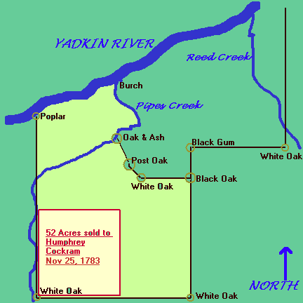
An interesting note is that Nathaniel Morris in 1787 purchased the piece of property just east and north of this property, bordering on Pipes' Creek, the Yadkin and the line as described by the black oak, white oak and then back to Pipes' Creek, in general, the land surrounding the words "pipes creek" on the map to the right.
In 1999 a generous offer was made to me by Mr. Al Hudson who is a resident of Yadkinville and has a great deal of interest in local history. He agreed to take some photos of the area near Pipes' Creek so that we could get a flavor of the area. He was not able to get into the creek, as the underbrush in that area is very thick, but sent several photos of the area.
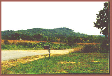
This first photo is looking south westerly from the area around Pipes' Creek toward Stars Peak or "Fox Nob"
Looking North from Highway 67. Pipes' Creek flows northward to the river in the wooded area at the rear of the picture.
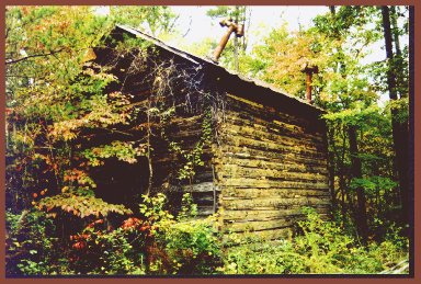
Looking east at a point just north of Highway 67. The river is just to the left in this picture. This land would have been part of the original property deeded to John Senior.
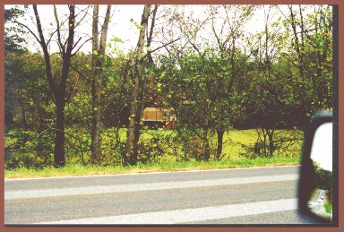
An old Tobacco barn that is on the original property. It lies between Highway 67 and the river also.
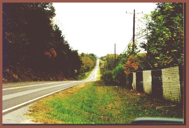
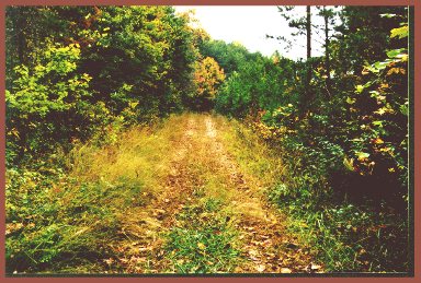
Looking East on Highway 67. Pipes Creek crosses at the bottom of this hill.
A Topographical Map of the area of Pipes Creek. Caution: its a large file, be patient.
In 1783, just one year after the deed was recorded, John Senior and his wife Priscilla sold off the 250 acres, making quite a profit and then removed their family south to Spartanburg, South Carolina. The first sale was of 52 acres on the southwest corner of the property to Humphrey Cockerham. A drawing of the property sold to Humphrey is based on the deed description recorded in 1783 and signed by John and Priscilla.
The remainder of the property was sold to Peter Downey who later sold the property to William Cook. Humphrey later purchased additional property of 100 acres adjoining this purchase to the west.
The 52 acres to Humphrey was sold for 50 pounds and the 198 acres to Peter Downey was sold for 100 pounds. So John Senior made a profit of 145 pounds on this property.
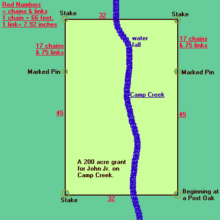
Now we can turn our focus to the land held by John Junior. This land was on the north side of the Yadkin river and was described a as rectangular property of 200 acres that straddles the creek called Camp Creek. This creek is located north of the town of Elkin and flows to the south and then east into the Mitchell River and thence into the Yadkin. It makes you wonder if he would have been able to travel to his father's property by traversing down Camp Creek to the Mitchell River and then to the Yadkin and west or upstream to Pipes' Creek. You can see this path on one of the previous drawings in this series.
 John
Pipes Junior made a purchase grant for this 200 acres of land recorded in
December of 1778. He paid into the state treasury the sum of 10 pounds for
each 100 acres, or 20 pounds total when the deed was recorded in May of
1779. The entry says that it includes improvements previously made by a
William Davis.
John
Pipes Junior made a purchase grant for this 200 acres of land recorded in
December of 1778. He paid into the state treasury the sum of 10 pounds for
each 100 acres, or 20 pounds total when the deed was recorded in May of
1779. The entry says that it includes improvements previously made by a
William Davis.
The date for the original survey for this property is interesting. It is entered as December 1778, when his widow said they did not move to N. Carolina until 1779 or 1780. Either he traveled to the state to secure the property or possibly someone else entered the land warrant for him. In any case, John Junior lived there with his family for about 15 years
The land was sold to a William Alford in October of 1795 and recorded in mid 1796. It is recorded in Deed book I, page 161. The deed selling the property is signed by John Pipes and his wife Mary. This was just prior to their move to Kentucky.
The man who was responsible for recording the information connected to land transactions in Surry County during this period (1771 to 1800) was Joseph Winston. He maintained an entry book that holds brief descriptions of each transaction. In 1987 the book for 1778 to 1781 was transcribed and published. Several interesting entries connected to the Pipes family are included. We list them here for possible areas of further research and for proof of several points. The entry numbers are from the original Joseph Winston entry book, the page numbers are from the 1987 book. I transcribed these entries verbatim from the 1987 book. Sentences enclosed in braces are from the 1987 book, not comments by myself. My comments, if any are in blue after each entry.
1. Entry # 109, Page 11 - Peter Eason enters 300 acres of land in the County of Surry situate and lying near the Yadkin River adjoining John Pipes line, William Silveas & Francis Callaways' beginning on said Pipes line then running agreeable to act of Assembly including my improvement - May 25, 1778. [Warrant granted] (This entry shows that John Pipes' line was already recognized in May of 1778)
2. Entry # 308, Page 28 - John Pipes enters 250 acre of land in Surry Co. on the S side of Yadkin River joining Eaton's line including my improvement for complement - July 23, 1778. [Warrant granted to H.S.] (The words "including my improvements" shows that John Pipes had made some additions to the property before filing the Warrant)
3. Entry # 427, Page 39 - John Parks enters 200 acres of land in Surry Co. on the S side of the Yadkin River beginning at the mouth of Pipes Creek running up the creek to the ford, to Pipes house thence E joining Peter Eaton's line thence crossing a creek to the top of a hill thence N including the improvement where William Silvey now lives - August 11, 1778. [Warrant granted to H.S. March 30, 1779 - entry withdrew per order, money returned.] (This entry places a location on the house that John Pipes was living in at the time. A very exciting entry! This implies that the Pipes house was at a ford of the creek and must have been located north of highway 67. The creek turns west after it crosses 67. The house would have been on the west side of the creek, as the creek was the property line.)
4. Entry # 442, Page 40 - Moses Woodruff enters 40 acres of land in Surry Co. on the head of John Pipe's Creek including the said Woodruff improvement for complement (no date given). [ March 10, 1778 - caveated by John Brown, "Wilks Co.; returned to court. Brown gave up to Woodruff, money returned. Warrant granted to Woodruff.] (This entry shows an even earlier date for identifying John Pipes' Creek - i.e. March of 1778)
5. Entry # 786, Page 70 - John Pipes enters 200 acres of land in Surry Co. on both sides of Camp Creek the waters of Michels River including the improvement that was William Davis's ( no date given). [December 8, 1778 - caveated by Nicholas Angle, returned to court. Jury found for Daviss.] (Gives a very early date for John Junior applying for a warrant of the land on Camp Creek i.e. 1778.)
6. Entry # 941, Page 83 - Silvanas Pipes enters 150 acres of land in Surry Co. on the Bigg Elkin including my improvement for complement - November 12, 1778. [Warrant granted to J.M.] (The Big Elkin is North of the Yadkin and this says that Sylvanus must have been there before this date because of the "improvements for complement" phrase.)
7. Entry # 1498, Page 130 - Nathaniel Morris enters 300 acres of land in Surry Co. on Eatons Creek waters of the Yadkin River adjoining Peter Eaton and John Pipes including the improvement that was William Silveys - March 30, 1779. [Transferred, warrant granted.] (This is the land East of John Pipes' property. The date is important to establish the date of Nathaniel's arrival in Surry Co. The improvements were not his, but were made by someone else.) (William Silvey or Silveas is mentioned in number 1, 3 and 7)
8. Entry # 2010, Page 171 - Silveness Pipes enters 150 acres lying on the Elkin joining his former entry - ( no date given). [Warrant granted; transferred.]
9. Entry # 2023, Page 172 - John Pipes Junr. enters 200 acres on the head of Hanes's Creek adjoining David Haramon including the Mine Hotel - (no date given). [Warrant issued by J.W., C.C., to H. Speer.] (I have no idea what this means yet. Needs more investigation.)
10. Entry # 2065, Page 175 - John Pipes enters 200 acres on Deep Creek waters adjoining William Roberts - April 24, 1780. [Warrant issued by J.W., C.C., to H. Speer.] (I do not know the meaning of this entry either, needs more work.)
SOURCES USED IN THIS ARTICLE:
1. Joseph Winston: His Entry Book, Surry County, NC Land Entries, 1778-1781, by Agnes Wells
2. Surry County, North Carolina Abstracts - Deed Book A, B, and C ( 1770-1778) By Mrs. W. O. Absher G.R.S.
3. Carolina Cradle - Settlement of the Northwest Carolina Frontier, 1747-1762 by Robert Ramsey
4. Index to Fred Hughes' "Historic Land Grant Map of Yadkin County" Compiled by Gary Cooper
5. A Map kit sold by the Yadkin County Historical Society.
6. Records of the Moravians In North Carolina Adelaide L. Fries, M.A. Vol II 1752-1775
7. The Great Wagon Road, Path of Settlement, Harbinger of Revolution by R. Kyle Stimson
8. The Heritage of Yadkin County and Heritage of Surry County. Pub by N.C. Historical Society
9. Photos and Maps supplied by Al Hudson of Yadkinville, N. Carolina in 1999
10. The working notes and papers of Mrs. Elsie Mae Amerine of Houston Texas. These papers were preserved and sent to me by John Hawkins in 1998. These papers documented the deeds concerned with John Pipes Junior and Senior in North Carolina.